SNN invites you to sign up for a subscription for our award winning site, with access to great stories and educational features. Obviously we are proud of our accomplishments, but we really want to share the truly engaging stories and custom features for the classroom and beyond.
As an ad-free site, SNN relies on subscriptions to enable it to produce this award winning educational website. Where else can you get daily updates of engaging stories and current events backed up by interdisciplinary activities and extra features?
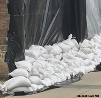
Sandbags are in place in front of businesses on 3rd Street SE in Cedar Rapids, Iowa on Saturday, Sept. 24, 2016. (Photo: Student News Net)
Thousands of sandbags were filled with sand over the weekend for placement in flood zones in Iowa, Illinois, and Missouri. In Cedar Rapids, thousands of volunteers filled about 14,000 sandbags for distribution throughout the downtown area.
Through the link below, the Department of Public Works in Los Angeles County has helpful information about sandbags for homeowners, including how to fill and place the bags for maximum benefit.
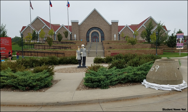
Sept. 26, 2016: Thousands of residents in eastern and central Iowa spent the Sept. 24-25 weekend filling and placing sandbags around buildings to protect against rising water predicted to reach flood stage in many locations. On Saturday, Sept. 24, 2016 at the National Czech and Slovak Museum and Library in Cedar Rapids, about 25 student volunteers from Coe College helped museum staff fill and place sandbags around the garage area of the museum and at historic buildings in the nearby Czech Village. Students were also deployed wherever needed in the downtown area. Ashley Glassberg, Coe College full-time staff member and AmeriCorps member, and Laura Formanek, director of marketing and communications for the museum, explained to Student News Net what the students were doing and the preparations that were being taken for the predicted flood. The Cedar River is forecast to crest at 23.0 feet early Tuesday, Sept. 27, 2016. On June 13, 2008, the Cedar River crested at 31.12 feet causing widespread damage in Cedar Rapids and other areas in Iowa. After the historic 2008 flood, the Czech Museum was moved to higher ground farther away from the river's banks.
The National Czech and Slovak Museum and Library in Cedar Rapids, Iowa is preparing on Sept. 24, 2016 for major flooding. Note the concrete extension of a manhole to the right with sandbags at its base. Also note the Grant Wood statue in the courtyard. It's the "Andy and Edie" entry in the Overalls All Over summer exhibition in Cedar Rapids. According to museum officials, the statue was being removed shortly after this picture was taken to protect it from flooding. The exhibition of 25 statues patterned after Grant Wood's famous “American Gothic” painting has now ended. (Photo: Student News Net on Sept. 24, 2016)
Questions
1. Through Primary Source Reference #1 below, what is the value of the many data collection capabilities the National Weather Service has in Cedar Rapids and other areas?
2. What are the dangers of trying to drive through flooded streets? Information can be found through Primary Source Reference #7 below.
3. Note rising levels of the Cedar River through Friday, Sept. 30, 2016 through the link provided in Primary Source References #1 below. Note levels periodically during that time frame. Graph your results. When did the river crest (highest point)? What conclusions can you draw from studying your graph? Prepare a presentation.
From the National Oceanic and Atmospheric Administration (NOAA):
Flood An overflow of water onto normally dry land. The inundation of a normally dry area caused by rising water in an existing waterway, such as a river, stream, or drainage ditch. Ponding of water at or near the point where the rain fell. Flooding is a longer term event than flash flooding: it may last days or weeks.
Flash flood A flood caused by heavy or excessive rainfall in a short period of time, generally less than 6 hours. Flash floods are usually characterized by raging torrents after heavy rains that rip through river beds, urban streets, or mountain canyons sweeping everything before them. They can occur within minutes or a few hours of excessive rainfall. They can also occur even if no rain has fallen, for instance after a levee or dam has failed, or after a sudden release of water by a debris or ice jam.
From the U.S. Geological Survey (USGS):
Flash flood
The result of heavy or excessive amounts of rainfall within a short period of time, usually less than 6 hours, causing water to rise and fall quite rapidly.
Flood
An overflow or inundation that comes from a river or other body of water and causes or threatens damage. Any relatively high streamflow overtopping the natural or artificial banks in any reach of a stream.
Flood frequency
Refers to a flood level that has a specified percent chance of being equaled or exceeded in any given year. For example, a 100-year flood occurs on average once every 100 years and thus has a 1-percent chance of occurring in a given year.
Flood plain
A strip of relatively flat-lying land that borders a stream and is underlain by sediment carried by the stream and dropped in the slack water beyond the influence of the swiftest current.
Flood stage
The stage at which overflow of the natural streambanks begins to cause damage in the reach in which the elevation is measured. Flood stages for each USGS gaging station are usually provided by the National Weather Service.
EXTRA! EXTRA! WRITING PRACTICE
Practice Your Writing Skills by summarizing what you've learned by reading, sharing and participating in this SLOG.